Contact Adam Lehmann with Hamilton County Conservation District (adam.Lehmann@Hamilton-co.org; 513-772-7645) with questions about the research highlighted on this page. We can get you in contact with a Team Lead as needed.
Tracking Progress & Evaluating Project Efficacy:
Collaborative partners have been monitoring in-stream hydrology, channel stability, habitat, and biology within the Creek (and a near-by “control” stream) since 2018. The first few years of monitoring were conducted prior to implementation of mitigation projects to establish baseline conditions in the Creek. We are now in the project implementation stage where we are installing cutting-edge hydrologic mitigation projects and closely monitoring to evaluate how these projects are affecting hydrology in the creek. The performance of these projects are being evaluated both individually and cumulatively
Instream monitoring efforts are a collaborative effort between multiple partners from University of Cincinnati (Department of Biology and Department of Geosciences), multiple laboratories within the U.S. Environmental Protection Agency (U.S. EPA), the Ohio State University, and Hamilton County Conservation District.
Watershed Modeling:
Over time, instream observations will be the ultimate “stick” used to measure cumulative success of the mitigation projects in achieving more natural flow patterns in the creek; however, hydrologic/hydraulic modeling is a critical tool as well. As we begin to simulate the cumulative effects of multiple projects - currently with U.S. EPA's Storm Water Management Model (SWMM) - the modeling will also allow us to partition the incremental hydrologic improvements to various projects – enabling us to compare the effectiveness of each project/project type. Additionally, this modeling enables us to simulate projects before they are implemented to prioritize those projected to be the more effective and optimize designs.
Modeling Efforts are being led by Partners at the University of Cincinnati's Geography Department and the Hamilton County Conservation District.
Developing Rapid Methods of Assessing Stream flow Duration:
Headwater streams, the relatively small streams with relatively small drainage areas (of which Upper Cooper Creek is an example), are important resources that represent the majority of our total “river miles” and suffer disproportionate impacts from urbanizations (and agriculture). The natural flow patterns of these streams are highly variable and dependent upon many factors. This flow pattern variation result in variation is the ecosystem service provided and has regulatory implications. Accordingly, U.S. EPA has conducted extensive research into the factors that correlate with the flow patterns exhibited, and ecosystems services provided by, headwater streams. U.S. EPA has also developed tools and methods to assess headwaters streams.
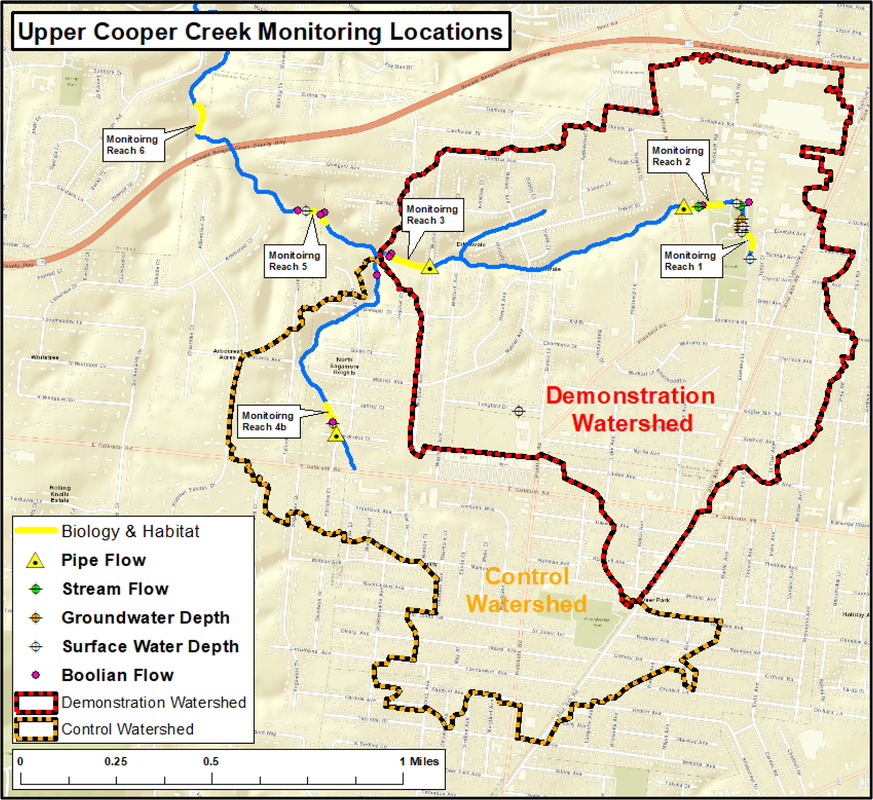
Currently, U.S. EPA is developing regional scale Stream Duration Assessment Methods (SDAMs) across the nation. Several sections of Upper Cooper Creek and its tributaries are part of this nation-wide effort. This effort involves assessing hydrological, geomorphological, and/or biological indicators, observable in a single site visit, to develop methods for rapidly classifying the flow status of a given stream section as perennial, intermittent, or ephemeral. We are very lucky that Cooper Creek is a part the SDAM effort because that effort involves installation of flow/no-flow sensors in many locations (see pink "Boolean flow" points on the map above) that are helping us to get a better understanding of where and when the creek is flowing (and drying-out).
"The Urban Karst" - Are Underlaying Sanitary Sewers Draining the Creek?
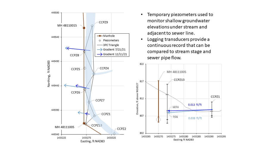
U.S. EPA, the Metropolitan Sewer District of Greater Cincinnati, and Hamilton County Conservation District, have been monitoring water losses from a 400-foot reach that flow only ephemerally despite perennial flows directly upstream and downstream of this location ( the wooden foot bridge in Bechtold Park spans this ephemeral reach). Through a combination of monitoring 1) surface water flows, 2) groundwater elevations below the stream, and 3) flow within a sanitary pipe that is aligned beside (and a couple feet beneath) the Creek, the Collaborative has begun to assess where the water is going. The graphics below show how the groundwater elevation data indicates a hydraulic gradient from the stream toward the pipe.
Interestingly, the flows observed inside the pipe do not appear to account for all the water lost from the stream. One hypothesis is that the water is flowing through the graveled trench in which the pipe was installed (and may or may not be ending up in the pipe, or back in the stream, further downstream). Our Colleagues at the University of Cincinnati's (UC's) Department of Geosciences have stepped in to help test this hypothesis. UC has been awarded a grant from the Ohio Water Resources Center to conduct a series of geophysical measurements in the area that should result in images that can be used to identify preferential flow paths below the surface. This effort will result in the development of a more stream-lined methods for identifying pathways of stream flow losses that can be applied in other impacted streams. Read more about this geophysical investigation in the poster linked below.
Retrofitting Storm Sewers to Reduce the Frequency of Erosive Flash-Flows in Streams:
Can Existing Storm Sewers be Retrofitted to detain stormwater and reduce the frequency of erosive flash-flows in streams? Hamilton County Conservation District, U.S. EPA, and Trihydro (with financial support from the Ohio Environmental Education Fund) created a methodology and screening tool to help answer that question for specific locations.
These resources are meant to aid water resource managers to assess opportunities for implementing storm sewer retrofit projects to improve local stream stability and ecological integrity.
How Do Fish Move in Hydrologically Altered Urban Streams?
How do the unnaturally frequent and large magnitude erosive flash flows that occur in Cooper Creek affect the way that fish move through the creek? Researchers at the University of Cincinnati tagged fish with devices that enables their relocation during weekly surveys over the course of nearly a year. Click the link below to read about their findings.